Make a Splash in the Bend
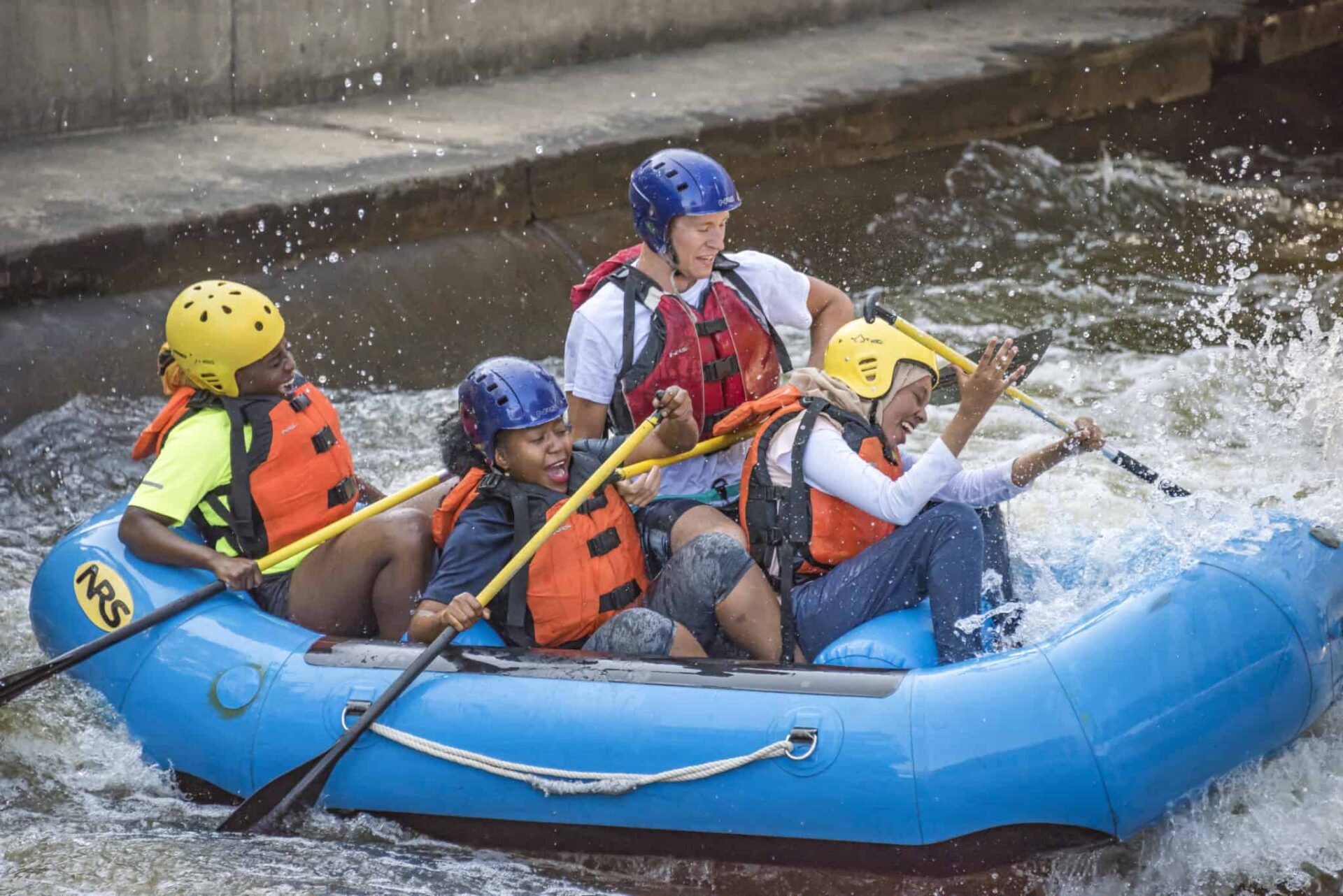
The East Race Waterway in downtown South Bend is the first man-made whitewater rafting course built in North America. Since opening in 1984, over 400,000 residents and visitors have ridden down the East Race with paddles in hand and smiles on their faces.
Once a driver of industry producing heat and electricity, the East Race Waterway now produces class 2 rapids and lifelong memories for rafters and kayakers to test their skills and have some summer fun. Every steep drop and every big splash are all a part of the thrill of white water rafting in downtown South Bend. You may even hit one of the rapids and be thrown into the water. You and your fellow rafters will have to work together to keep a steady path as you battle all the twists, turns, and drops along the 1,900-foot-long course.

Connected walkways and bridges along the course will allow your family and friends to cheer you on and take photos of your journey down the rapids.
Spanning twelve miles along the St. Joseph River and connecting South Bend and Mishawaka, the Riverwalk begins and ends in serene and lovely parkways— the 398-acre St. Patrick’s County Park at the northern edge and at the eastern most point, Mishawaka’s Central Park. Along the way, the walk leads past the campuses of both Notre Dame and Indiana University South Bend, the venerable South Bend Farmers Market, Potawatomi Zoo, Park and Conservatories and downtown South Bend.

From Mishawaka, the St. Joseph continues on to Elkhart where, in the bustling downtown, it converges with the Elkhart River. A boardwalk, lined with restaurants and stores, is just steps away from the easily accessible Historic Island. Also close by are Ruthmere, a Beaux Arts-style mansion open for tours and the 36-acre Wellfield Botanical Gardens. Here a series of outdoor garden “rooms” are settings for sculptures, water features, bridges and winding pathways.
Tres Rios

The waters of St. Mary’s, St. Joseph, and Maumee Rivers flow together in northeast Indiana near the Ohio border, which is why General “Mad” Anthony Wayne, the Revolutionary War hero, built a fort here in 1794. Now the rivers of Fort Wayne are more about recreation than winning battles. That’s why the city’s “Riverfront Fort Wayne” development group, led by the city’s Parks and Recreation department, was established and are helping the riverfront evolve and develop into a center of activity and powerful source of regional pride.
The history of the Fort Wayne waterways is carried on with the introduction of Sweet Breeze, a 54-foot replica of an authentic 1840’s canal boat. The flat bottom boat takes passengers on either a 45- or 90-minute tour offering scenic views
of the three rivers. Fort Wayne Outfitters and Bike Depot, which organizes the cruises, also offers sunset rides leaving from The Deck at Hall’s Gas House. Wine and other beverages are available for purchase at boarding.

But that’s not the only way to travel along the rivers. The Gas House also offers airboat rides on weekend nights. Fort Wayne Outfitters not only rents kayaks, canoes and stand-up paddleboards but takes people on a 90-minute land and water tour on Fort Wayne’s duck boat, an amphibious vehicle built for quick land-to-shore and back trips for troops and supplies during World War II. FW Outfitters is also the launching point for Captain Black’s pontoon tours which travel along the St. Mary’s and St. Joseph rivers as they wind through Fort Wayne’s downtown. The tours are private and can host up to 12 passengers. The city has also developed several water trails for paddlers (kayaks and canoes can also be rented from Earth Adventures) and, for joggers, walkers and cyclists, the 25-mile Rivergreenway Trail running along the banks of the three rivers through 15 parks as it connects Fort Wayne and New Haven.
Tippecanoe: An Ancient Native American Pathway
A designated Canoe Trail and named one of the Top Ten most important freshwater systems in North America by The Nature Conservancy in Rivers of Life: Critical Watersheds for Protecting Biodiversity, the Tippecanoe River flows through the 40-acre Winamac Town Park.
“It’s looked at as the gold standard of streams for biological cleanliness by the Indiana Department of Natural Resources,” says Krysten L. Hinkle, Project Coordinator for the Pulaski County Community Development Commission. “It winds through the towns of Monterey and Winamac and has inspired many other designated recreational areas, including the Tippecanoe River State Park and a designated Canoe Trail.”
The park, which Hinkle describes as phenomenal, features the Soldier & Sailor Memorial Suspension Bridge—a pedestrian bridge crossing the river. For watercraft, there’s Riverside Rentals.
A Trail Through History
In lovely historic Richmond, Indiana the spectacular Whitewater Gorge Trail rambles past Thistlethewaite Falls, one of the state’s largest cataracts and the site of several old mills, now long gone. Try the southern route that winds past the remains of Starr-Gennett Piano Company and Recording Studio where several jazz greats including Louie Armstrong and Hoagy Carmichael cut their tunes (look for the stars in the cement) and parallels the river.
Sugar Creek
Surrounded by lush scenery and diverse wildlife, Sugar Creek provides many excellent recreational opportunities. Sugar Creek is a swift-moving waterway that sprawls nearly 100 miles from its source in Tipton County to its confluence with the Wabash River.
creek flows, and each year visitors flock to the area because of its scenic beauty and the fact that it has one of the largest drops (five feet) per mile of Indiana waterways. Sugar Creek is a favorite destination for canoers and kayakers, and is frequently cited as Indiana’s most beautiful waterways for these activities. Annual events on the creek include the Friends of Sugar Creek Canoe Race and the Family Friendly Float Trip. In addition to having one of the largest drops, Sugar Creek has towering riparian trees and dramatic sandstone bluffs that line the banks. Scenery along Sugar Creek includes historic mills, covered bridges and variety of wildlife, such as soft-shelled turtles, white-tailed deer, great blue herons and bald eagles.
Along the Ohio
The Ohio River has played a vital role in the development of Evansville by providing trading and travel opportunities for the past two centuries. Evansville’s Riverfront and Dress Plaza follows the deep crescent- shaped bend in the river for more than a mile, from the Tropicana Casino to the LST memorial. Tropicana Evansville began as Indiana’s first riverboat casino. Today, the newly land-based complex has 45,000 square feet of state-of-the-art gaming space, top- flight restaurants, pubs, a piano bar, two riverfront hotels and a pavilion.
For more than a century, Evansville Museum of Arts, History and Science has been a wellspring of regional history. Exhibits include contemporary and traditional art galleries, Evansville’s role in WWII, and a 19th century river town visitors can stroll through.
Madison’s gem of a river walk encompasses the city’s storied past like the early 18th century Lanthier Winery with its gardens overlooking the water to the fast-moving present—the only jet boat tours on the river courtesy of Rockin’ Thunder Jet Boat Ride. Enjoy numerous river fests like the RiverRoots Music and Folk Arts Festival, Madison Regatta and the Madison Ribberfest BBQ & Blues.
Connecting three great cities—Jeffersonville, Clarksville, and New Albany, the Ohio River Greenway is studded with green spaces for picnicking, walking and biking paths, restaurants and retail and easy access to each of these distinctive downtowns.
River life is at the heart of Jeffersonville, Clarksville and New Albany, three Hoosier towns once known as the “Gateway to the North.”
More than 3,000 ships were launched on the Ohio River from this top U.S. city for steamboat production from the 1860s to the 1930s. Shipbuilding is highlighted at the Howard Steamboat Museum and Mansion, once located adjacent to the largest inland shipyard in the country.
Enjoy a stroll above the Ohio River on the mile- long Big Four Pedestrian and Cycling Bridge, connecting Jeffersonville to Louisville, Kentucky. Watch the sun set from Big Four Station Park before dining at one of several riverfront restaurants.
The Falls of the Ohio State Park and Interpretive Center in Clarksville has the largest, naturally exposed Devonian fossil beds in the world. Clark’s Point, George Rogers Clark’s home, provides a panoramic view of the falls.
Once the largest city in Indiana, New Albany was where more than half the Hoosiers worth $100,000+ lived. Today, experience the glories of the Victorian era at the Culbertson Mansion with hand-painted trompe l’oiel designs and stunning plasterwork. Nearby, the Riverfront Amphitheater holds free concerts and festival.
Corydon was Indiana’s first capital and offers historic day trips, attractions, and family activities. There’s something for everyone including five wineries, two underground caves and a casino. One of the best riverfront restaurants in the state, the Overlook, is in nearby Leavenworth and offers a 20-mile panoramic vista of the Ohio River.
www.thisisindiana.org
The Wabash River
The Wabash Heritage Trail offers visitors unique wildlife and unparalleled views along this 18-mile scenic trailway that begins at Tippecanoe Battlefield in Battle Ground and meanders along Burnett Creek to the Wabash River in Lafayette and West Lafayette. It ends at Fort Ouiatenon. Trail maps and conditions are available at the Wah-ba-shik-a Nature Center, Tippecanoe Battlefield Park. Bicyclists will enjoy the 5-1/2 miles of paved trail in Lafayette and West Lafayette. And, while you’re in the area, be sure and take a ride back in history at the Wabash & Erie Canal Park in Delphi. Enjoy a 35-minute floating trip on “The Delphi,” a replica 19th-century canal boat. Tour guides share adventures and stories of everyday life as it was 150 years ago on the Wabash & Erie Canal.
www.homeofpurdue.org
Canal Boat Ride in Carroll County
Experience history, adventure and pure spring/summer fun at the Wabash and Erie Canal Interpretive Center. This attraction, 20 minutes north east of Lafayette-West Lafayette, offers an adventure for the whole family. The canal boat ride takes you through a portion of the original Wabash and Erie Canal and a whole pioneer village to explore.
Terre Haute and Vigo County understand the economic and recreational impact waterways
have on local areas. The Wabash River is a big part of their community which is why they’ve created a “Riverscape Vision”, headed up by Wabash River Development & Beautification, Inc. Their goal is to “create a sustainable and active focal point” that includes family-friendly recreation, passive natural areas, and opportunities for education and interpretation about the river. The vision also includes compatible commercial and residential development. www.terrehaute.com


